
Your Guide to Conquering a Single-Day Presidential Traverse

The Presidential Traverse is easily one of the best hikes in New Hampshire. There’s nothing like trekking over the tallest peaks in the state. These summits reign over the land, and being within their presence is a powerful feeling. When you climb over them, you’ll truly feel like a warrior.
On this hike, you’ll climb over seven or eight official 4,000 footers: Mount Madison, Adams, Jefferson, Washington, Monroe, Eisenhower, Pierce, and for the extended version, Jackson. If your goal is to conquer a Presidential Traverse, then here’s everything you need to know about completing this hike in a single day.
How long is the Presidential Traverse?
The Presidential Traverse is a 20-mile hike that should only be attempted by experienced hikers. The elevation gain on this hike is anywhere from 9,000 to 10,000 feet, which is why it takes hikers a long time to complete.
How long does it take to hike the Presidential Traverse?
The Presidential Traverse often takes hikers anywhere from 15 to 18 hours to complete due to the difficulty of the terrain and elevation gain, although time may vary based on hikers’ speed and endurance. To complete a Presidential Traverse in a single day, hikers should start as early as possible. It’s common for hikers to go southbound and begin around 2:00 am in order to catch a sunrise on Mount Madison. This still allows optimal time to complete the hike before sunset in the summer. If you plan on completing this hike at any other time of year, expect less daylight.
How to Hike the Presidential Traverse
Train Your Body
The Presidential Traverse is not for the faint of heart. This hike traverses the most difficult terrain in all of the White Mountains, but that doesn’t make it unachievable. By taking it one step at a time, you’ll be able to safety prepare for your body and mind for a single-day Presidential Traverse.
A great way to prepare your body for this hike is by strength training for hiking since it helps hikers sustain different movement patterns on trail and improve muscular endurance. In addition, improving cardiovascular endurance, either by doing consistent cardio at the gym or building stamina with longer and harder hikes, will help hikers complete a Presidential Traverse.
Pack the Right Gear
For this hike, you will need the ten essentials, a wind breaker and insulated jacket, and of course, proper hiking shoes and a hiking backpack. When the huts and Sherman Adams Summit Building are open, you will be able to fill up on water at Madison Spring Hut, the summit building, and Lake of the Clouds Hut, meaning you can carry less water weight on the hike.
Prepare for Safety
Always check the Higher Summits Forecast for accurate weather predictions prior to your hike. In addition, prepare at least one bail out point, such as off Jewell Trail from Mount Jefferson or Washington, if the weather changes abruptly and you need to bail. Your safety always comes before accomplishing a big goal. The mountains will always be there.
Completing this hike in winter should only be attempted by very experienced adventurers. To prepare for a winter ascend, please read more about winter hiking the Presidentials.
The Presidential Traverse
A view that’s worth the climb.
September 3, 2022
Appalachia Trailhead, 2:30 am
Headlamp? Check. Snacks? Check. Okay, deep breathe. Did I pack too much gear? Not enough? What if I run out of water before getting to Mount Washington? Did I lock my Jeep at every access point? Am I going to get through the day okay? What am I even doing right now?
The anticipation has been building up for months. After training my body with consistent, difficult hikes all summer long and getting little-to-no sleep in my tent last night—just like that, it's time to go. I strap on my pack, tie my trail runners on my feet, and take the first step on the trail with my friends.
Valley Way Trail, heading toward Mount Madison, 2:35 a.m.
It is nowhere near dawn. In fact, the sun still has several hours left to sleep. I can tell that my body is begging for it too—with every step, I feel a wave of exhaustion pull me backwards like the ocean during low tide. Luckily, Valley Way is a very gradual trail. It is a nice warm up for the day ahead.
We got this.
Conversations between my friends and I begin to pickup as our minds and bodies shift into waking mode. We begin with few words—perhaps due to a mix of exhaustion and nerves for what lies ahead of us: eight peaks, almost 8,000 feet of elevation gain, 19 miles, and for me, doing it all on barely two hours of sleep.
We finally break treeline and walk the narrow path that leads to Madison Spring Hut. I have never seen the stars in the sky look so clear. For a moment, I forget about the what-ifs and doubts of the day ahead weighing on my mind. Instead, all I can focus on is the vastness of space and that we all have the ability to reach for the stars.

Heading up Osgood Trail to Mount Madison.
Stopping at the hut is tempting, but knowing how long of a day we have ahead of us, we only pause there for a brief moment before ascending Osgood Trail for a short half mile to the summit of Mount Madison. Plus, we intend to catch sunrise, and it is already 5:35 a.m. The sun will rise around 6 a.m., so we have to move. As we turn the corner, we see the colors of the sky turn from midnight blue to a vibrant combination of pink and orange. The sky reflects a magical silhouette around my friends. I watch in the distance with gratitude as my friends I run to get ahead of the sun.

Mount Adams from Osgood Trail
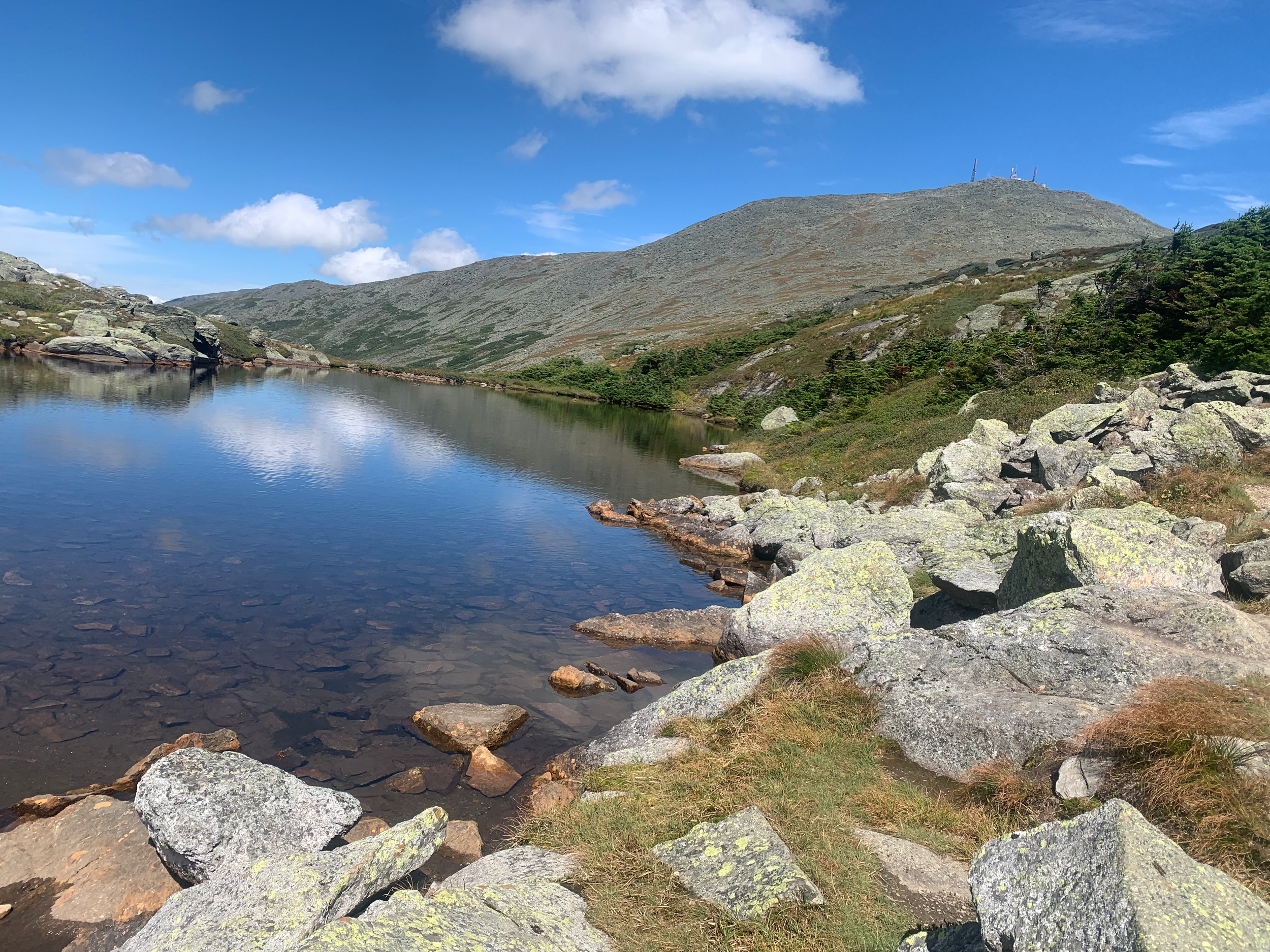
Starr Lake Trail, heading toward Mount Adams, 6:40 a.m.
We are over five miles and still hours away from the next water spot, Mount Washington, so I fill my water bladder at the hut. We begin our next phase of the journey to Mount Adams. I step over roots and rocks and past Starr Lake, which glistens in the sunlight. I am amazed at how fast the sun has risen. Already, the cold and dark trek up Valley Way feels like it was yesterday, yet we are still just beginning our day.
Starr Lake Trail is not the common route for hikers doing a Presidential Traverse. The trail is quite rocky and, steep, but is only 1.1 miles to the summit and offers wide-open view of Mount Madison and Starr Lake. Most hikers will choose to ascend Mount Adams via Gulfside to Airline Trail, which is more gradual, but longer.
My legs have finally adapted to the consistent incline, making it a bit easier to make big step ups over the wobbly rocks I must conquer. What I love about this trail is how you can basically see it in it's entirety from start to finish. We continue to climb up the rock wall before stepping into the section that appears right before the summit of Mount Adams.
For a brief moment, I am alone, and a deep feeling of solitude takes over. I stop in my tracks to admire the beauty of the earth surrounding me. There is not a breeze of wind, a cloud in the sky, nor another human in sight. In this moment, I do not fear the mountains of the Presidential Range. Instead, they welcome me with open arms, and I feel as if I am right where I belong.
We enjoy the summit to ourselves for a few minutes before continuing onward.
Gulfside Trail, heading toward Mount Jefferson, 7:25 a.m.
We arrive to the Thunderstorm Junction and it hit me, we are in this now. With the sun higher in the sky and more carbohydrates in my system, I felt a rush of energy and excitement run through my body. We begin hiking along Gulfside Trail and within the Great Gulf. This is quite a special spot. We seamlessly move in and out of the bushes and enjoy views of the unique rock formations of the Great Gulf Wilderness, one of the oldest and smallest wilderness areas in the state.
After the easy walk on Gulfside Trail, we push 0.8 miles to the summit of Mount Jefferson. We stop here for a few minutes and mentally prepare for the last big push of the day to the tallest summit in the state—Mount Washington.
Gulfside Trail, heading toward Mount Washington, 9:00 a.m.
I do not think we could have picked a better day for a Presidential Traverse. The air is crisp—a telling sign that fall is coming—the sky is a bright baby blue, and the sun is glistening over the ridge we are walking on. We decide to summit Mount Clay, which is easily my favorite summit in the White Mountains. Even though the summit sits at 5,533 feet, it’s not on the official 4,000-footer list. At this point, Mount Washington looks within reach.
The total distance from Mount Jefferson to Washington is only 2.4 miles, but we are feeling the exhaustion and heat now, so it seemed further. Not only are there no clouds in the sky, it is also just about noon, so the sun is beaming down hard. We hike alongside the cog and push to the Sherman Adams Summit Building. Finally, we can use a real bathroom, eat more filling food, and rest our legs for a minute. It’s an empowering feeling to know where we started, while others at the table next to us simply just took the cog up here.

Continuing Onward
Crawford Path, heading toward Mount Monroe, Eisenhower, and Pierce,12:45 p.m.
After rejuvenating at Mount Washington, the 1.5-mile hike down to Lake of the Clouds Hut is a breeze. Conversations are beginning to pick up, and everyone is feeling pretty good. After stopping at the hut for a few minutes, we climb 0.3 miles to Mount Monroe, the fifth official 4,000-footer of the day. A few of us are needing to stop every few steps to regain energy. It’s crazy to think about how much we’ve climbed today, and yet we are still moving. Limits truly only exist in the mind.
A few of our friends met up with us on Mount Monroe. The excitement of seeing them gave us new energy to get through the last part of the traverse. For the 2.1-mile trek to Mount Eisenhower, conversations are high and keeping our minds off of being tired. At the summit, I feel myself hit a wall of exhaustion. The 1.2-mile hike down to the Webster Cliff Trail Junction feels like a daze. In this moment, I take it one step at a time and reflect on where I began my day. We are too close to quit now.
Finally, we climb an easy 0.1 miles to Mount Pierce and I hug the cairn like a best friend I hadn’t seen in years. The 3.2-mile hike down Crawford Path to the cars feels like forever. We finally arrive to the Crawford Connector, where we dropped a few cars, and feel more proud of ourselves than we ever have before.
Now, where’s my beer?