
5 Easiest 4,000-Foot Mountains in New Hampshire
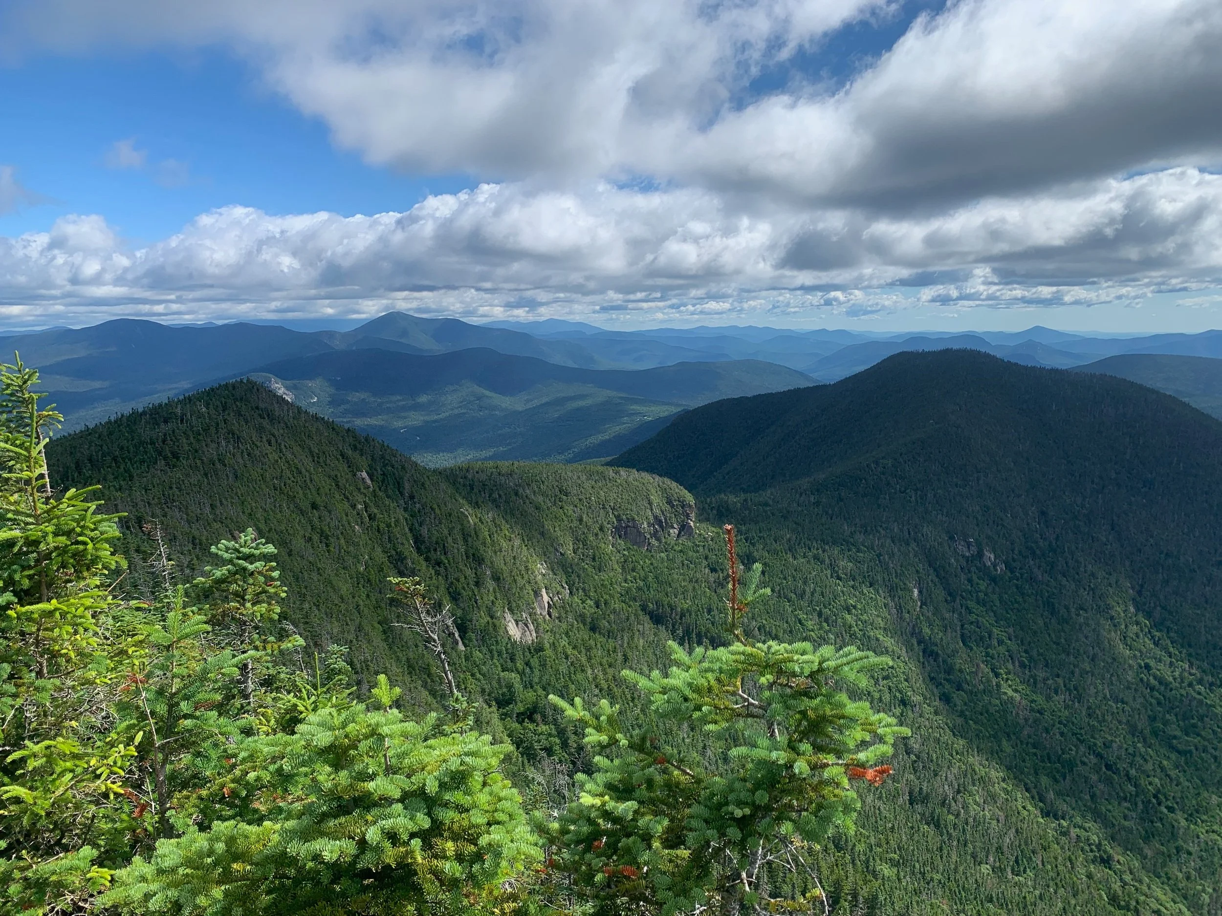
Looking into the Sandwich Range Traverse from the summit of Mount Osceola.
There is a place where gray jays fly through hemlock and black spruce trees, wind howls at high elevations through piles of bedrock and gravel, and thousands of hikers are working toward their goal of climbing every mountain higher than 4,000 feet in the state. This mighty place is known as the White Mountains in New Hampshire. While these mountains may not be as high in elevation as the 14ers out in Colorado, their ruggedness, difficulty, and beauty should not be underestimated. In fact, it’s what makes them such a special place in the New England region.
From steep inclines to rocky terrain, the White Mountains attract hikers all over New England and beyond for the challenge, yet reward that they provide. Forty-eight of these summits sit above 4,000 feet. It’s not hard to get hooked on climbing them once hikers discover the joy of being immersed in their wilderness areas.
If you’re unsure where to begin your journey, it’s ideal to start with hikes that aren’t too long in miles and have a little less elevation gain. As someone who has completed the New Hampshire 48, I found the following 4,000-foot mountains to be the easiest to start with. Please note that just because these mountains are the easiest on the 4,000-footer list does not mean that they’re easy in general.
What to Bring on a Hiking Trip
The most important part of hiking is being prepared. While hiking, you’re often going to be hours away from the trailhead, so having all of the essentials to keep you safe, comfortable, and content is key. To begin, locate a nearby outdoor recreation store in your area, such as an Eastern Mountain Sports (EMS) or Recreational Equipment, Inc. (REI) store where you can try on and gather all of the necessary gear. If you’re on a budget, many of these stores will have a used gear section where you can buy items at a better price.
Here’s a list of what you’ll need to go hiking:
Hiking boots or trail runners: Having a pair of hiking shoes that are comfortable, durable, and provide good traction are important when you’re walking for hours in the woods. If you have a bad pair of shoes, you may be dealing with blisters, falls, and a miserable day.
Hiking backpack: The right pack will vary by person, so trying on a few brands and figuring out the right size for your body type is key. Ask an employee at an outdoor recreation store to help you find the right fit. For a day hike in the spring, summer, or fall, a backpack between 10 and 25 liters should be enough. If you plan on winter hiking or backpacking, then you’ll want to opt for something bigger.
Jackets: I say jackets because depending on the day, you may need both a soft shell and hard shell. Soft shell jackets will keep you warm and a hard shell jacket is made to break the wind or keep you dry in rainy conditions. Look for jackets that are lightweight, breathable, and packable.
The 10 essentials: You’ll need to carry a map and compass, knife or multi-tool, extra food, extra water, extra layers (moisture-wicking, lightweight, and breathable), protection (sunglasses, sunblock, and bug spray), shelter (emergency blanket or bivvy), first aid kit, headlamp with extra batteries, and a fire starter.
Other items to consider: a satellite device, trekking poles, portable battery pack, wet wipes or toilet paper, chapstick, and hand sanitizer.
Please note that hiking in the winter requires more gear. If you’re just starting out, I recommend gaining experience in the late spring, summer, or early fall before getting out there during the colder months.
Tips for Hiking the White Mountains in New Hampshire
In addition to packing, there are a few other things to do before heading up to the White Mountains for a hike. You’ll want to be aware of things such as the predicted weather, trail conditions, and the parking situation.
Check the weather: Knowing the weather for the day you plan to hike is crucial. The White Mountains are home to Mount Washington, which is known for the world’s worst weather. Even the summer can bring cold temperatures that may potentially lead to hypothermia and other safety concerns. Some good places to check the weather are the Higher Summits Forecast, National Weather Service, and Mountain Weather Forecasts.
Know your route: Even though many trails in the White Mountains are easy to follow and blazed, you can still get lost, especially when there are multiple trails on a single mountain. Before your hike, be aware of the total miles, trail names, any notable points on the trail, river crossings, and recent trail condition reports. In addition to carrying a paper map, you can use apps like Gaia GPS and AllTrails to track your route.
Get a hike safe card: By purchasing a Hike Safe Card, you’re protecting yourself from needing to pay rescue costs unless the actions that required a rescue meet criteria set forth by legislation.
Arrive to the trailhead early: The White Mountains are a popular place for hikers. Arriving early can increase your chances of finding a parking spot. I’ve never had to turn around because there was no parking, but I’ve been forced to park on the side of the road a few times where it’s allowed.
Bring cash or a pass for parking: While most recreation areas are free to use, some developed sites require a fee. You can either pay the $5 fee in cash when you arrive, or you can purchase an annual recreation pass to make the parking process easier for yourself.
Tell someone where you’re going: No matter how short or easy a hike may be, telling someone you trust of your hiking plans adds another layer of safety to your day.
When to Hike Mountains in New Hampshire
The best time to hike is the summer or fall. Summer offers longer days and access to huts and fall provides beautiful colors of red, orange, and yellow. For beginners, early spring can be tricky because there is still snow at higher elevations. It’s also wet and muddy, the water crossings are higher, and there are snow bridges which can be dangerous for someone unfamiliar with technical hiking. Winter is a beautiful time of year to hike, but you should get comfortable with hiking in general first before getting out there during the colder months.
5. Mount Moosilauke via Gorge Brook Trail

The view from the summit of Mount Moosilauke.
2,513 feet of elevation gain; 7.1 miles out and back.
Located in the Kinsman Range, Mount Moosilauke is not only an easier hike for beginners, it’s also one of the most beautiful hikes in the White Mountains. The summit offers all-around views of the White Mountains, and on a clear day, you’ll spot summits in Vermont, such as Mount Mansfield. Gorge Brook Trail is an easy-to-follow, gradual trail within a stunning forest that takes you to the top in about 3.6 miles. I’ve done this hike three times and it usually takes me about four hours to complete. If you want to catch views from South Peak, you can make this hike a loop instead of an out and back. Mount Moosilauke is 4,802 feet—making it the 10th tallest 4000-footer in the state.
4. Mount Waumbek via Starr King and Kilkenny Ridge Trail
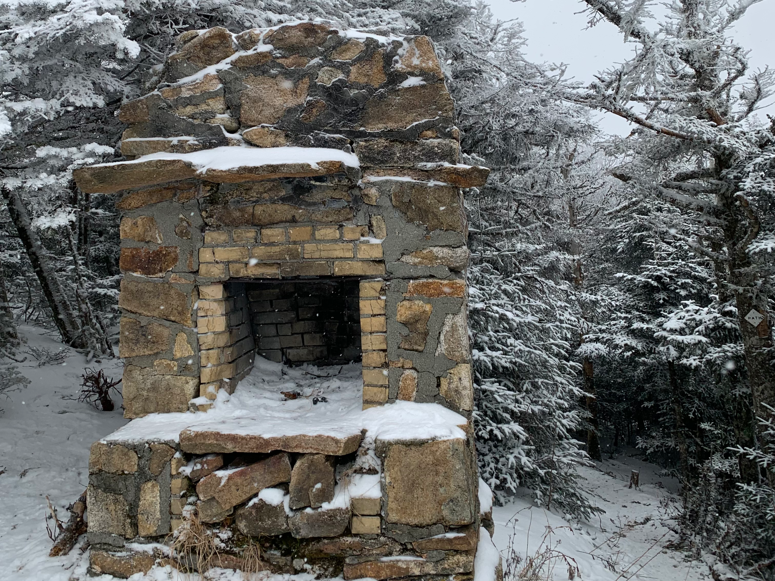
When you get to the top of Mount Starr King, you’ll stumble across this old fireplace.
2,736 feet in elevation; 6.7 miles out and back.
Located in the Pliny Range, this remote summit follows Starr King and Kilkenny Ridge Trail, which is a tranquil, gradual trail that goes over Mount Starr King where you can check out a beautiful view and stone-built fire place. Mount Waumbek does not offer any views, but it’s still a lovely hike if you’re looking for something not too challenging. Depending on where you’re coming from, this summit is quite far for most people, so it may be worth finding somewhere to stay so you can also hike Mount Cabot while you’re up there, which is the northernmost 4,000 footer. Mount Waumbek is 4,006 feet–making it the third shortest 4,000-footer in the state.
3. Mount Tecumseh via Mount Tecumseh Trail
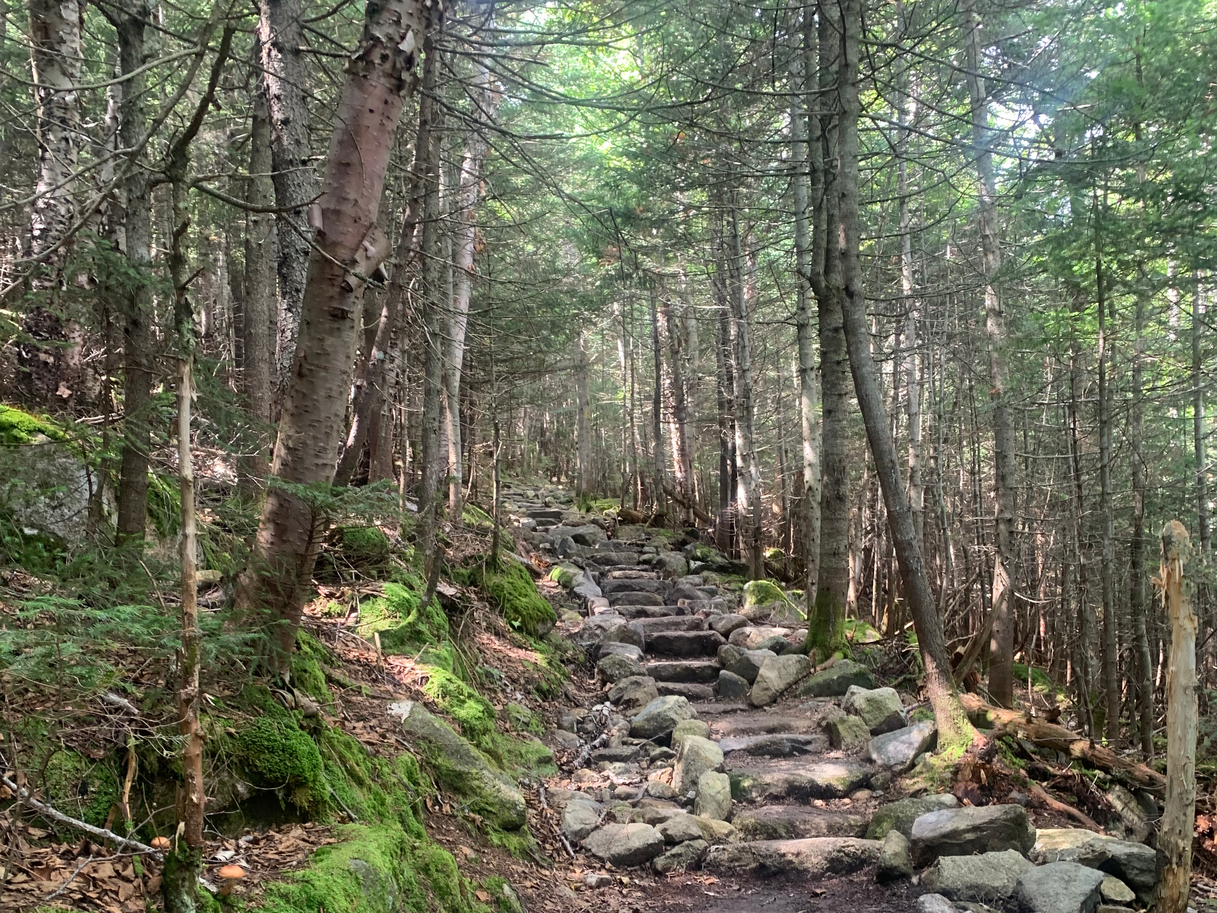
The stairs heading up to the summit.
2,283 feet in elevation; 4.9 miles out and back.
Located in the Sandwich Range and Waterville Valley, a ski area, Mount Tecumseh is easy to get to for people coming from the south. What makes this one easy is that the trail to get to it, Mount Tecumseh Trail, is short, but it still has the reputation of being like an outdoor StairMaster. While these steps are built to support hikers, I find that it makes the trail a bit more of a workout. Either way, Mount Tecumseh is a great way to get your feet wet with hiking the 4,000 footers. Plus, getting comfortable with your hiking gear at lower elevations and less miles is always ideal. At 4,003 feet, Mount Tecumseh is the shortest 4,000 footer.
2. Mount Pierce via Crawford Path
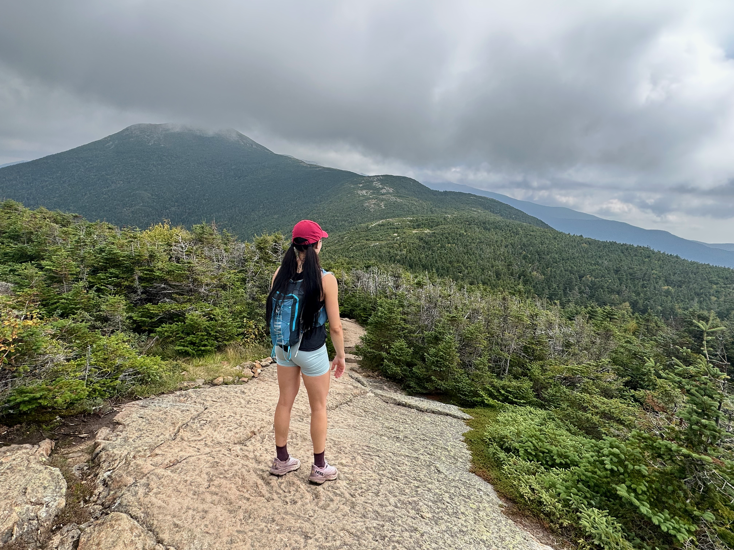
Looking at Mount Eisenhower from a lookout point right before the summit of Mount Pierce.
2,398 feet in elevation; 5.9 miles out and back.
Mount Pierce via Crawford Path is one of my favorite hikes. Did you know that Crawford Path is the oldest maintained hiking trail in the United States? The trail was built in the 1800s and used as a horse trail. It goes all the way to the summit of Mount Washington. A popular hike for many is to just take the trail to Mount Pierce, which sits in the southern part of the Presidential Range. On the way up this gradual trail, you can check out Gibbs Falls before making your way up to amazing views of other peaks in the range. For those who want to push themselves a little further, hike a bit more to Mount Eisenhower. Mount Pierce is 4,310 feet—making it the 27th tallest peak in the state.
1. Mount Osceola via Mount Osceola Trail
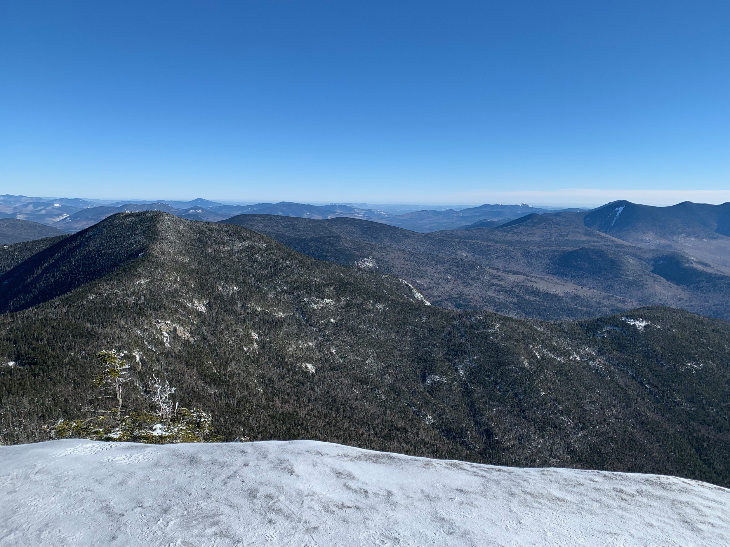
View from Mount Osceola in the winter.
2,040 feet in elevation; 6.3 miles out and back.
Mount Osceola is one of the most popular hikes in the White Mountains due to the steady incline of Mount Osceola Trail and the incredible views from the summit, so if you plan on hiking it in the summer, be sure to get there early. I’ve hiked it several times, and although it’s obtainable for beginners, the trail is still pretty rocky. For a bigger push, you can tag East Osceola, which offers no views, but the hike there goes over the chimney, which is a fun scramble that can be bypassed. Located in the Sandwich Range, this is another peak that’s easy to get to from the south. Mount Osceola is 4,340 feet—making it the 24th tallest summit in the state.
Looking at the 4,000-footer list as a whole can be daunting, but by starting small, you can work your way up to more challenging peaks as you gain more knowledge, experience, and confidence. If you plan on hiking all 48 peaks, you can apply to become part of the AMC Four Thousand Footer Club once you’re done, and you’ll be rewarded with a patch. To support your hiking journey, I recommend finding some companions who may just become life-long friends. Check out Hiking Buddies NH 48 or even Redline Guiding if you’d prefer to go with a guide. All in all, just take the list one peak at a time, and I promise you’ll get there. Happy hiking!